The HYSPLIT-based Smoke Forecasting System

The NOAA Smoke Forecasting System integrates the NOAA NESDIS information on the location of wildfires with NOAA National Weather Service inputs from the North American Mesoscale model into smoke dispersion simulations from the NOAA ARL HYSPLIT model to produce a daily 48-hour prediction of smoke transport and concentration. The model also incorporates U.S. Forest Service estimates for wildfire smoke emissions based on vegetation cover. This system is intended as guidance to air quality forecasters and the public for fine particulate matter emitted from large wildfires and agricultural burning which can elevate particulate concentrations to unhealthful levels.

ARL is developing the HYSPLIT-based Emissions Inverse Modeling System (HEIMS) to estimate wildfire emissions from the transport and dispersion of smoke plumes inferred from NOAA GOES satellite observations. HEIMS uses the smoke transport patterns captured by geostationary satellites with a high temporal resolution as a constraint under a general four-dimensional variational (4D-Var) data assimilation scheme. The model combines information from NOAA ARL, NOAA NESDIS and the US Forest Service to produce updated fire emissions. The ARL-developed HYSPLIT is the core engine for HEIMS, and products are intended for future use in the operational smoke forecast system.

  • Current Smoke Forecasts – Current smoke forecasts being produced by NOAA.
  • Smoke Verification – Use of analyzed smoke from satellite imagery to verify smoke forecasts.
  • HYSPLIT Model Details – Brief description of the Smoke Forecasting System.
  • Relevant Links – See below for resources for monitoring forest and wildland fires and smoke.

Official NCEP FVS Smoke Verification Using GOES AOD Product

Smoke Forecasting System Verification Products

The following verification products are made available for evaluation purposes only. For a history of model changes refer to the smoke forecast model change log. This evaluation consists of a GIS shapefile match between the smoke plumes derived by a NOAA NESDIS satellite analyst using the Hazard Mapping System (HMS) and the HYSPLIT modeled smoke (PM2.5) concentration shapefiles.

Smoke Verification of CONUS Operational Forecast

Smoke Verification of Alaska Operational Forecast

Smoke Verification of Hawaii Operational Forecast

For current smoke forecasts, see https://www.nws.noaa.gov/aq/.

For HYSPLIT ensemble smoke forecasts, see Probabilistic smoke products.

Operational Smoke Forecasts

NOAA currently uses the Smoke Forecasting System to predict the transport and dispersion of wildfire smoke over the United States, Alaska and Hawaii. These forecasts can be found at: https://airquality.weather.gov/

Video published on YouTube Jun 29, 2012 by NOAA Visualizations

HYSPLIT Smoke Forecasting Papers, Posters, and Presentations

Inverse modeling of fire emissions constrained by smoke plume transport using HYSPLIT dispersion model and geostationary observations. Kim, H. C., Chai, T., Stein, A., and Kondragunta, S.  (2020), Atmos. Chem. Phys., 20, 10259–10277, https://doi.org/10.5194/acp-20-10259-2020

Ensemble PM2.5 Forecasting during the 2018 Camp Fire Event Using the HYSPLIT Transport and Dispersion Model. Li, Y., Tong, D. Q., Ngan, F., Cohen, M. D., Stein, A. F., Kondragunta, S., et al. (2020). Ensemble PM2.5 forecasting during the 2018 Camp Fire event using the HYSPLIT transport and dispersion model. Journal of Geophysical Research: Atmospheres, 125, e2020JD032768. https://doi.org/10.1029/2020JD032768

Evaluating a fire smoke simulation algorithm in the National Air Quality Forecast Capability (NAQFC) by using multiple observation data sets during the Southeast Nexus (SENEX) field campaign. Pan, L., Kim, H., Lee, P., Saylor, R., Tang, Y., Tong, D., Baker, B., Kondragunta, S., Xu, C., Ruminski, M. G., Chen, W., Mcqueen, J., and Stajner, I.: Geosci. Model Dev., 13, 2169–2184, https://doi.org/10.5194/gmd-13-2169-2020

Description and Verification of the NOAA Smoke Forecasting System: The 2007 Fire Season, Rolph, G.D; Draxler, R. R.; Stein, A.F.; Taylor, A; Ruminski, M.G.; Kondragunta, S.; Zeng, J,; Huang, H.; Manikin, G.; McQueen, J.T.; Davidson, P.M., Weather and Forecasting, *24, *361-378, 2009.  https://doi.org/10.1175/2008WAF2222165.1

Verification of the NOAA Smoke Forecasting System: Model Sensitivity to the Injection Height, Stein, A.F.; Rolph, G.D.; Draxler, R.R.; Stunder, B.; Ruminski, M.G., Weather and Forecasting, *24*, 379-394, 2009 https://doi.org/10.1175/2008WAF2222166.1

Regional real-time smoke prediction systems, Susan O. Neill, N. Larkin, J. Hoadley, G. Mills, J. Vaughn, R. Draxler, G.Rolph, M. Ruminski, and S. Ferguson, Wildland Fires and Air Pollution, A. Bytnerowicz et al., Eds., Developments in Environmental Science Series, Vol. 8, Elsevier, 499-534.

Use of Environmental Satellite Imagery for Smoke Depiction and Transport Model Initialization, Mark Ruminski, Shobha Kondragunta, Roland Draxler and Glenn Rolph, 16th International Emission Inventory Conference, Raleigh, North Carolina (5/07).

Recent Changes to the Hazard Mapping System, Mark Ruminski, Shobha Kondragunta, Roland Draxler and Jian Zeng, 15th International Emission Inventory Conference, New Orleans, Louisiana (5/06).

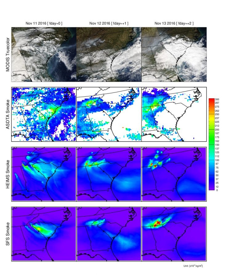
Spatial distributions of observed and forecasted fire smoke plumes on November 11-13, 2016; True-color image from MODIS (1st row), ASDTA smoke (2nd row, converted from AOD), HEIMS smoke hindcast (3rd row), and SFS smoke forecast (4th row, from operation) are shown
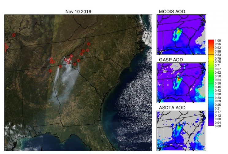
Detection of fires over the southeastern region of the United States on November 10, 2016: True-color image from MODIS (left), MODIS AOD (top right), GASP AOD (middle right) and smoke AOD (bottom right)

Relevant Smoke Forecasting links

Fire Detection and Smoke Analysis

Satellite Imagery

MODIS

GOES

TOMS

Fire and Smoke Analysis Products

Other (for case studies)