

The Boundary Layer is the most dynamic in Earth’s atmosphere as a result of constant exchange and interactions with the land/water surface. This interface, where the exchanges of energy, momentum, moisture, gases, and aerosols take place, is where weather and climate begin. The exchanges of heat and water vapor between the land and atmosphere are largely driven by the surface radiation budget, a combination of incoming and outgoing short and longwave radiation. Understanding the processes and environmental variables that control surface-atmosphere exchanges, and translating this understanding into more accurate model parameterizations, is a vital research activity that improves weather, climate and air quality predictions. ARL has a widely-recognized expertise in this area of research and collaborates with other OAR laboratories, other federal agencies and university partners to advance knowledge in this area and transition this understanding to improved NOAA products and services.

ARL performs field measurements to better characterize the exchange of chemical species between the Earth’s surface and the atmosphere. Surface-atmosphere exchange rates of reactive nitrogen (nitrogen oxides and ammonia) are highly uncertain and difficult to model. These species serve important roles in the formation of air pollution and their removal back to the Earth’s surface can have harmful environmental consequences. Working with universities and other federal agencies, ARL helps to quantify the extent to which fluxes affect air quality and pollutant removal at selected locations around the US. ARL also performs field studies to investigate the processes that influence the exchange of reactive nitrogen and other compounds between the atmosphere and land surface, with a focus on agricultural regions and urban areas. The results of these measurements and the improved scientific understanding of the processes that influence the exchange rates can be used to improve computer models of these compounds on local and regional scales.

Air Quality: Fire Weather
Wildfires release a huge amount of aerosols and trace gases into the atmosphere, which significantly affect weather, climate, air quality and human health. Since 2000, an annual average of over 71,000 wildfires have burned an average of 6.9 million acres in the U.S. Nearly 4.5 million U.S. homes have been identified at high or extreme risk of wildfire, with more than two million in California alone. Financial losses from wildfires have totaled over $5 billion over the past ten years. A warmer and drier climate is expected to lead to more frequent and intense fires near or within populated areas. Widespread burning in spring and summer is rapidly becoming the new normal in the western U.S. ARL performs research to improve flux estimations of trace gases and aerosols from wildfires and their impacts on weather and air quality.
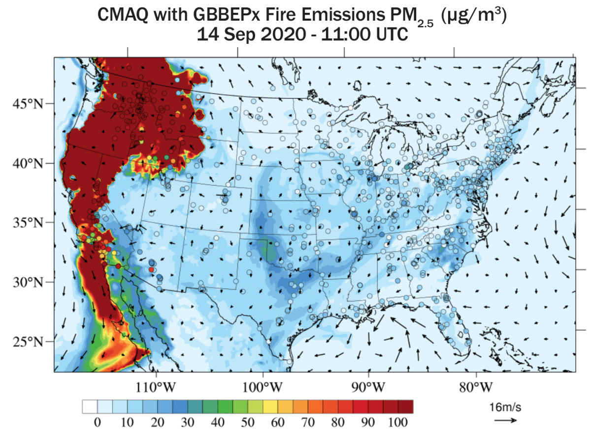
Surface PM2.5 concentrations on September 14, 2020 predicted by the Community Multiscale Air Quality (CMAQ) model, which uses the NESDIS Blended Global Biomass Burning Emissions Product (GBBEPx) to represent wildfire sources
Air Quality: Dust Research
Dust lifted from the Earth’s surface naturally by winds or by human activity can reduce incoming solar radiation, alter the structure and intensity of storms and precipitation, and seriously impact air quality and human health. As with wildfires, a warmer and drier global climate will likely lead to increased frequency of large dust events and result in larger atmospheric effects. ARL’s research on atmospheric dust emissions dates back to the 1970’s and recently has resulted in improved global dust emissions estimates in the National Weather Service’s global aerosol model. Ongoing dust research at ARL aims to further refine dust estimates and extend their accuracy across time and space.
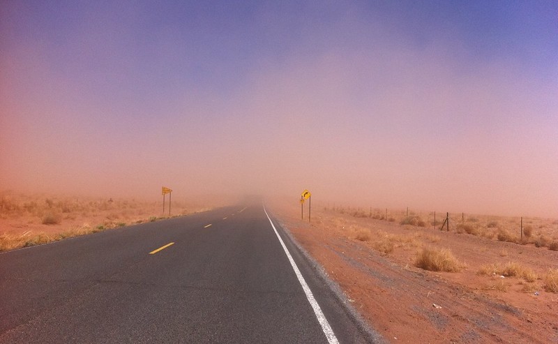
Dust storm near Winslow, AZ in April 2011. Seth Munson, USGS.
Air Quality Modeling and Forecasting
ARL scientists use the new knowledge gained in surface-atmosphere exchange research to improve computer models employed by NOAA’s National Weather Service (NWS) to forecast air pollution episodes over the U.S. As of 2021, the NWS’s National Air Quality Forecasting Capability (NAQFC) provides 72 hour forecasts of surface ozone and atmospheric fine particles (PM2.5). Exposure to high concentrations of PM2.5 has been linked to numerous health problems including asthma and cardiovascular disease. Accurate air quality forecasts enable communities to take actions that may reduce the severity of episodes. These predictions also allow individuals to take protective actions to minimize their own exposure to poor air quality. The research done by ARL scientists to increase understanding of surface-atmosphere exchange is motivated by the need to improve the simulation of these processes in the large-scale air quality models used by the NAQFC to generate these forecasts.
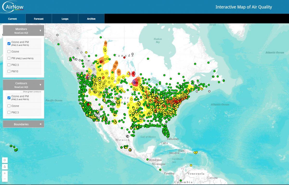
Nationwide air quality forecast maps indicate areas of concern for poor air quality.