Transport-Dispersion Modeling

Developed and maintained by ARL, HYSPLIT is the core engine of ARL’s transport-dispersion modeling activities and it is one of the most widely used models for atmospheric trajectory and dispersion calculations in the US and internationally. HYSPLIT is a complete system for computing simple air parcel trajectories as well as complex transport, dispersion, chemical transformation, and deposition simulations. Some examples of its applications include tracking and forecasting the release of radioactive material, wildfire smoke, windblown dust, pollutants from various stationary and mobile emission sources, allergens and volcanic ash. ARL’s dispersion products are not only used for operational applications at the NWS but also by other US government agencies, academia, and private companies.

HYSPLIT is under continuous development at ARL in collaboration with internal and external partners. The model evaluation activities described below are fundamental to this development as they provide objective assessments of model performance and allow hypotheses to be generated and tested. Quantification, and attempts to reduce uncertainty, is a related, core effort underpinning HYSPLIT development.


READY: Real-time Environmental Applications and Display sYstem

READY (Real-time Environmental Applications and Display sYstem) has been developed to allow users to access and display meteorological data products and to run the HYSPLIT transport and dispersion model on the NOAA Air Resources Laboratory’s (ARL) web server. READY brings together dispersion models, meteorological display programs and textual weather forecast programs generated over many years at ARL into a form that is easy to use by anyone. Its primary user group, however, is atmospheric scientists.

A research paper providing an overview of READY titled Real-time Environmental Applications and Display sYstem: READY  is publicly available. Any research papers published using READY products should include a reference to this paper. The paper is designed for air quality forecasters, emergency responders, government agencies, atmospheric research and aviation community.

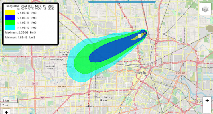
HYSPLIT Atmospheric Dispersion predictions for Nov 11, 2020, northeast Houston area smoke plume. The WFO provided these plots to the Houston Office of Emergency Management to inform the public alerts and response options.
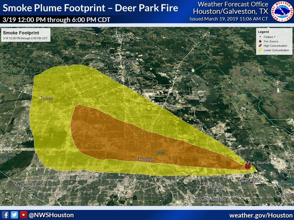
Graphic depicting the location of the fire and modeled concentrations of the smoke footprint color coded for high or low concentration. Extends West from near Deer Park, across Houston, to/past Cypress, TX.
Probable smoke plume dispersion derived from HYSPLIT. Credit: NOAA NWS
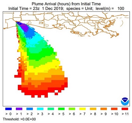
Port Neches at left indicated by red + on a map showing the outline of counties in the general area. Four colors shown, indicating chemical dispersion > 1 hour to > 11 hours after the model was run.
HYSPLIT time of arrival plot for hazmat/industrial pollutant originating from the Port Neches, TX plant on December 1, 2019.

Model Evaluation Activities (MONET v2.0)

ARL released MONET v2.0, an open source project and Python package that aims to create a common platform to analyze atmospheric composition data for weather and air quality models. First developed by ARL scientists in 2016, MONET’s original purpose was to evaluate the Community Multiscale Air Quality Model (CMAQ) for NOAA’s National Air Quality Forecast Capability (NAQFC) modeling system. Used for both implementation of the CMAQ 5.0.2 model upgrade and NAQFC emission upgrades, MONET calculated statistics and visualizations, showing model bias comparisons versus the U.S. Environmental Protection Agency’s AirNow stations in near real-time for variables such as ozone and PM2.5 (particulate matter smaller than 2.5 microns).

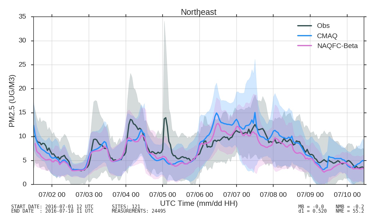
MONET evaluation of the performance of CMAQ, NAQFC and observational data over the Northeastern US.

In developing v2.0, MONET’s architects focused on a modularized approach to data analysis with a goal to provide high-level tools to retrieve, read and combine datasets in order to speed scientific research. The resulting update features the ability to pair model output to observational data in space and time, and leverages the pandas and XArray Python packages for analyzing and visualizing data. Furthermore, the process introduces a convenient method for evaluating model output, organizing data in a manner that results in easy searchability and groupings by meta-data found within the observational datasets. Common statistical metrics, plotting routines and more are included in the package, which is modularized to permit various additional observational datasets and models. In addition, MONET’s interaction with multidimensional observations and model output was re-engineered to use a XArray Accessor, augmenting the functionality of an existing library and expanding capabilities that ultimately ensure ease of use for its clients and contributors. Further enhancements are already in work, including increased satellite and model integration, the addition of bilinear interpolation and the inclusion of additional measurements.

MONET v2.0 is available at https://github.com/noaa-oar-arl/MONET.git. For more information please visit http://monet-arl.readthedocs.io or contact Barry Baker at Barry.Baker@noaa.gov.