

February 24, 2023 Update
About NOAA’s HYSPLIT
The NOAA HYSPLIT model is used to simulate the direction and dispersion of substances– including hazardous materials– through the atmosphere. It is used for emergency response by NOAA’s National Weather Service (NWS). NWS offices run the model during local coordination with agencies responding to emergency events, and the NWS Pittsburgh office provided model output to partners as a component of their decision support during response efforts to the East Palestine trail derailment. A basic version of the model is also available to the public.
About the Air Resources Laboratory web story and graphics
The NOAA HYSPLIT graphics included in the February 8 post from NOAA’s Air Resources Laboratory (see ARL Weekly News below) are a piece of information that emergency managers use as part of their analysis to make decisions for public safety. The graphic on the right shows the vertical distribution of air above the train derailment incident, with the blue colors showing air movement in higher altitudes (up to about 32,800 feet/10,000 meters) and the black showing air movement in lower altitudes (less than 9,840 feet /3,000 meters), at a snapshot in time on the evening of February 7.
This type of graphic does not show pollution levels near the ground where people live and breathe. The concentration of pollution decreases dramatically as you go downwind, which is not demonstrated in this particular graphic.
The graphic on the left shows the estimated concentrations near the surface (0-328 feet/0-100 meters above the ground) of a generic pollutant arising from a hypothetical release of 1 gram per hour. It shows how the plume is estimated to disperse as it travels downwind, over the time period of 6:00-7:00 pm EST on February 6. The analyst running the HYSPLIT model can choose the domain and scale of the map.
The story and graphics were posted on February 8, 2023. The graphics briefly dropped off the story and were quickly restored, unchanged. Here is the ARL web story: https://www.arl.noaa.gov/arl-
For the latest on the East Palestine train derailment response and investigation
In the case of the Feb. 3, 2023, derailment of Norfolk Southern freight train carrying hazardous chemicals in East Palestine, Ohio, NOAA is referring all media inquiries to the U.S. EPA and FEMA’s Interagency Modeling and Atmospheric Assessment Center, the federal agency leads for the latest information on the response and investigation. See this special EPA webpage with a general hotline number and disaster updates: https://www.epa.gov/oh/east-
ARL Weekly News – February 3, 2023
| Recent Events |
Train Derailment in East Palestine, Ohio.
A eastbound Norfolk Southern train bound for Conway Pennsylvania, derailed in East Palestine, Ohio, on Friday, February 3, 2023 at 8:55PM. About 50 cars derailed; of those, 20 contained hazardous materials and four contained vinyl chloride. While no injuries were apparent from the immediate derailment, the fire spanned the length of the rail cars and continued for several days. At least one vinyl chloride car is intermittently leaking contents through a pressure release device.
The local Weather Forecasting Office has been using HYSPLIT runs to monitor the situation and the resulting plume rise of the vinyl chloride. The leaking vinyl chloride poses a health hazard to humans, and several area neighborhoods have been evacuated as a result of this accident. An evacuation order was in effect within a mile of the train crossing as of early Saturday, and the town set up barricades to deter residents from returning. Vinyl chloride is a colorless, flammable gas that is associated with an increased cancer risk in those exposed to it. It is used to make hard plastic resin such as polyvinyl chloride (PVC) pipes, wire coatings, vehicle upholstery, and plastic kitchen ware.
The EPA and Norfolk Southern are monitoring air quality.
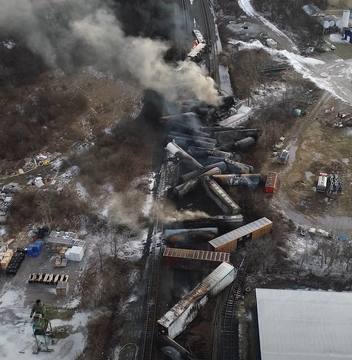
NTSB uncrewed aerial vehicle footage of the burning railcars in East Palestine, Ohio. The drone is the safest means to assess the situation. Image credit: NTSB


WMO Global Climate Observing System presentation
As a member of the WMO’s Global Climate Observing System (GCOS) Surface Reference Network (GSRN) Working Group, on February 6th Dr. Howard Diamond in his role as the U.S. Climate Reference Network (USCRN) program manager for ARL, made a virtual presentation on USCRN data products involving how the requirements for such products are collected and what products are available to the GSRN Task Team on Data Products. Given that the GSRN is largely modeled on the USCRN, the Task Team was very interested in how the USCRN approached this aspect of the observing effort.
| Upcoming Events. |
Preparation for Super Bowl LVII
When Super Bowl LVII kicks off on Sunday, February 12, 2023, a number of emergency management centers around Glendale, Arizona, will support the event with meteorologists from the Weather Forecasting Office in Phoenix, using tools such as ARL’s HYSPLIT. NOAA meteorologists help the event managers prepare for, and respond to, any potential atmospheric release of an airborne substance. NOAA’s Air Resources Laboratory in College Park, Maryland supports the local response team efforts for by performing frequent modeling runs to predict atmospheric conditions around the event.
In preparation for Super Bowl LVI in 2022, NOAA’s Air Resources Lab not only increased the frequency of HYSPLIT simulations, but also added more frequent runs and additional sites around Los Angeles. The outcome was successful and is being repeated this year. For this year’s game day in Phoenix, automated HYSPLIT runs are set up for several locations in the area, which are updated hourly and incorporate HRRR meteorology for most recent meteorology.
Phoenix is also hosting a golf tournament on the same weekend, so inbound traffic and tourism is expected to be heavy. The weather forecast for Sunday currently calls for partly cloudy conditions in the mid 60’s with a small chance of showers. Further updates can be found at the Phoenix WFO page.