

Wildfire Smoke Emission Estimation through HYSPLIT-based Inverse Modeling with Satellite Data
October 23, 2020
Margaret Simon
ARL has developed the HYSPLIT-based Emissions Inverse Modeling System (HEIMS) to estimate wildfire emissions from the transport and dispersion of smoke plumes inferred from NOAA GOES satellite observations. HEIMS uses the smoke transport patterns captured by geostationary satellites with a high temporal resolution as a constraint under a general four-dimensional variational (4D-Var) data assimilation scheme. The model combines information from three government agencies (NOAA ARL, NOAA NESDIS, and the US Forest Service) to produce updated fire emissions. The ARL-developed HYSPLIT is the core engine for HEIMS, and products can be used in the operational smoke forecast system.
An analysis using a November 2016 wildfire event was conducted to test the performance of the HEIMS products. The event was a series of wildfires in the southeastern United States in October and November 2016. The U.S. Forest Service reported at least 80,000 acres burned from October 23 to December 9, 2016. For the case study, we focused on the fire event that occurred in Georgia, South Carolina, North Carolina, and the adjacent states from November 10 to 17, 2016. Figure 1 shows fire smoke detected via satellite from the MODIS true-color image and three Aerosol Optical Depth (AOD) products from MODIS, GOES Aerosol/Smoke Product (GASP), and Automated Smoke and Tracking Algorithm (ASDTA) on November 10, 2016. Wildfires in the Appalachians of northern Georgia, western North Carolina, and eastern Tennessee began to produce large smoke plumes moving southeast. Numerous smoke plumes could be seen from active wildfires burning across the region. The HEIMS smoke emission estimates yielded results closer to observations than BlueSky emissions in simulations of smoke dispersion for this case (Fig. 2).
ARL is working to extend this inversion-based emissions-estimating system to include VIIRS aerosol products from the Suomi-NPP and JPSS-1 (NOAA-20) satellites. The team is also working to generate an operational method to provide high-quality emissions estimates on an ongoing basis to support current wildfire events. These data-assimilated emissions estimates will be used in HYSPLIT-based wildfire smoke forecasts and will also be made readily available to other smoke forecast systems (e.g., HRRR-Smoke).
Further details, including performance data on HEIMS, are discussed in detail in: Kim, H. C., Chai, T., Stein, A., and Kondragunta, S.: Inverse modeling of fire emissions constrained by smoke plume transport using HYSPLIT dispersion model and geostationary satellite observations, Atmos. Chem. Phys., 20, 10259–10277, https://doi.org/10.5194/acp-20-10259-2020, 2020. https://acp.copernicus.org/articles/20/10259/2020/
Other uses of HYSPLIT for smoke forecasting are described on the HYSPLIT page.
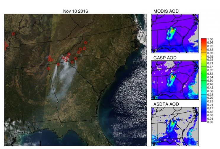
Detection of fires over the southeastern region of the United States on November 10, 2016: True-color image from MODIS (left), MODIS AOD (top right), GASP AOD (middle right) and smoke AOD (bottom right)
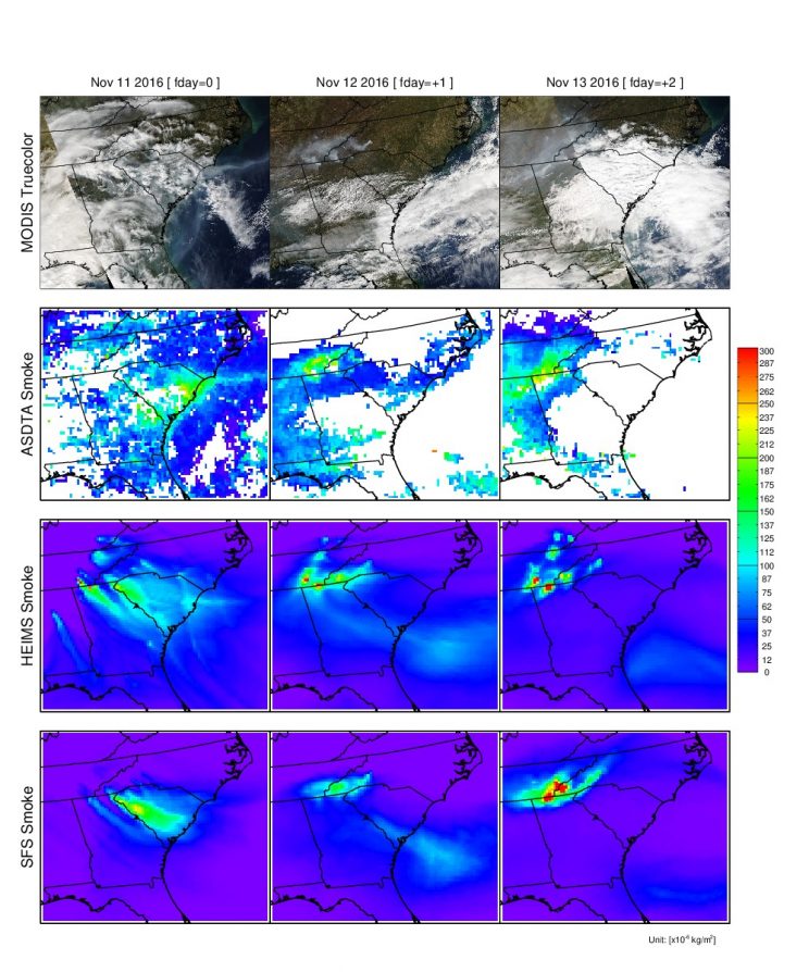
Spatial distributions of observed and forecasted fire smoke plumes on November 11-13, 2016; True-color image from MODIS (1st row), ASDTA smoke (2nd row, converted from AOD), HEIMS smoke hindcast (3rd row), and SFS smoke forecast (4th row, from operation) are shown