

ARL Weekly News – October 28, 2022
| Recent Events |
House Appropriations Staff Visit ARL
Staff members from the House Appropriations Committee visited the National Center for Weather and Climate prediction on October 25. ARL Director Ariel Stein provided an overview of the Laboratory and its current and future research. Following that, Howard Diamond provided a tour of the research facilities at ARL.
Ammonia Leak in Wichita Modeled by HYSPLIT
On October 25, WFO Wichita supported Sedgwick County Dispatch by modeling an industrial ammonia leak from a semitank leaking ammonia in north-central portions of Wichita on Tuesday evening. A HYSPLIT run was requested by the Wichita Fire Department. HYSPLIT predicted it was Acute Exposure Guideline Level 2 (AEGL-2) Event, indicating that the general population could experience irreversible or other serious, long-lasting adverse health effects.
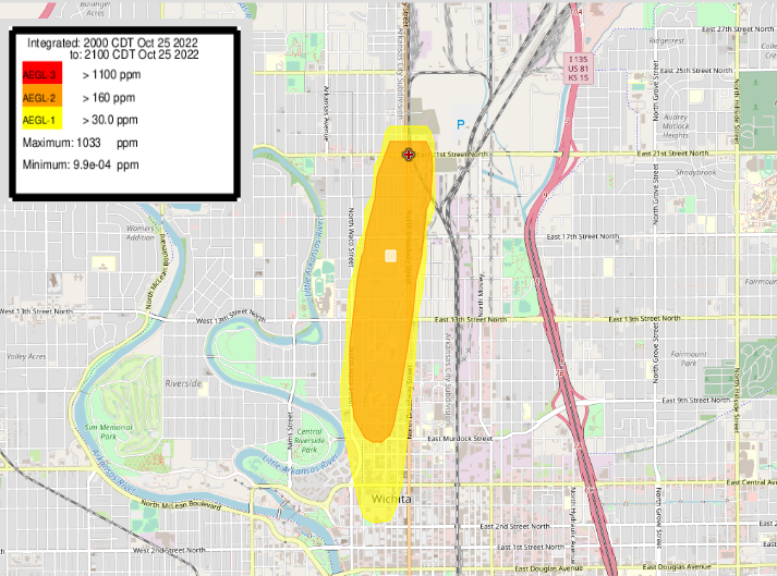
HYSPLIT predicted ammonia plume from October 25, leak in Wichita, KS.
Tropical Cyclone (TC) outlook for the 2022/23 Season
As part of his climate research work, Dr. Howard Diamond worked with the NOAA National Weather Service (NWS) Pacific Region Headquarters and Weather Service Office in Pago Pago, American Samoa, to provide input on the Tropical Cyclone (TC) outlook for the 2022/23 TC season in the Southern Hemisphere that begins on November 1, 2022, and runs through Aprl 30, 2023. The outlook has now been issued at https://www.weather.gov/ppg/AS_tropicalcyclone_outlook_2022-23 and the plot depicted here shows the expected frequency of TCs expected for the season based on past analog seasons during weak La Niña conditions. The graphic was created by using Dr. Diamond’s database of tropical cyclone best tracks for the southwest Pacific (from 135º East to 120º West longitude and south of the equator) back in 2011 as part of his PhD studies (see Diamond et al 2012). The database is called the Southwest Pacific Enhanced Archive of Tropical Cyclones (SPEArTC) and is publicly available (via free registration) at http://apdrc.soest.hawaii.edu/projects/speartc/register.php . The outlook was formally issued to the public by the NWS on November 1st.
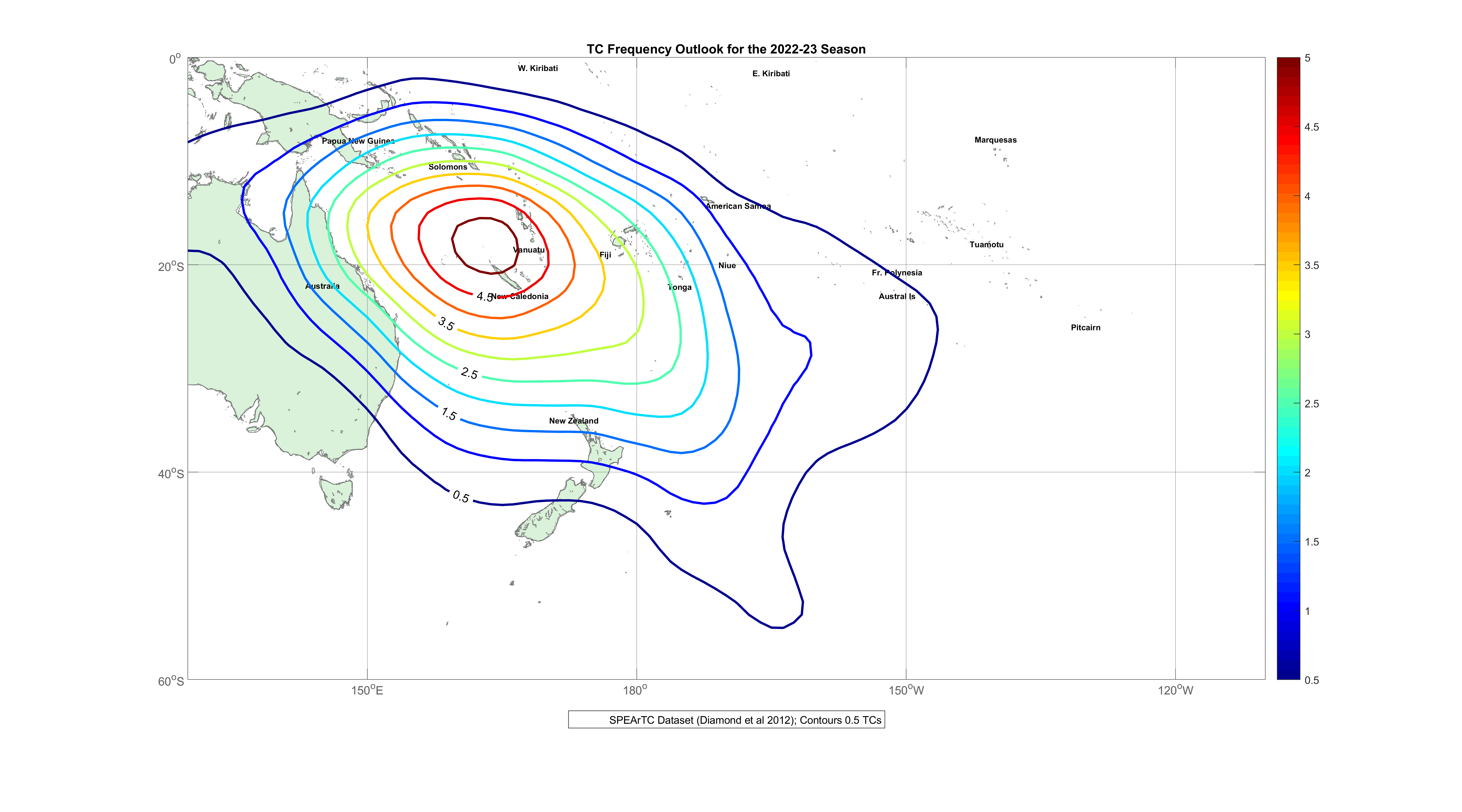
Tropical Cyclone (TC) outlook for the 2022/23 TC season in the Southern Hemisphere that begins on November 1, 2022, and runs through April 30, 2023.
Reference: Diamond, H.J., A.M. Lorrey, K.R. Knapp, and D.H. Levinson. 2012. Development of an enhanced tropical cyclone tracks database for the southwest Pacific from 1840-2011. International Journal of Climatology, 32: 2240–2250. DOI:10.1002/joc.2412.
Community Modeling and Analysis System (CMAS) conference
Patrick Campbell attended (in-person) the Community Modeling and Analysis System (CMAS) conference at UNC Friday Center in Chapel Hill, NC during Oct 17 – 19, and had an oral presentation on “Use of NOAA’s Global Forecast System Data in the Cloud for Community Air Quality Modeling” (as part of our continuing NOAA-OAR Cloud Incubator Project). This work is part of a collaborative effort at NOAA-ARL with Rick Jiang, Zachary Moon, and Sonny Zinn. The main objective of this work is to provide a cloud interface (Amazon Web Services) to GFS-driven Community Multiscale Air Quality (CMAQ) applications for any regional domain globally (see figure below). This system uses the NOAA-EPA Atmosphere Chemistry Coupler (NACC), the main meteorological interface to our current operational National Air Quality Forecasting Capability (NAQFC), as a new in-cloud processor of GFSv16 data that produces model-ready inputs for CMAQ applications in the community (i.e., “NACC-in-the-Cloud”).
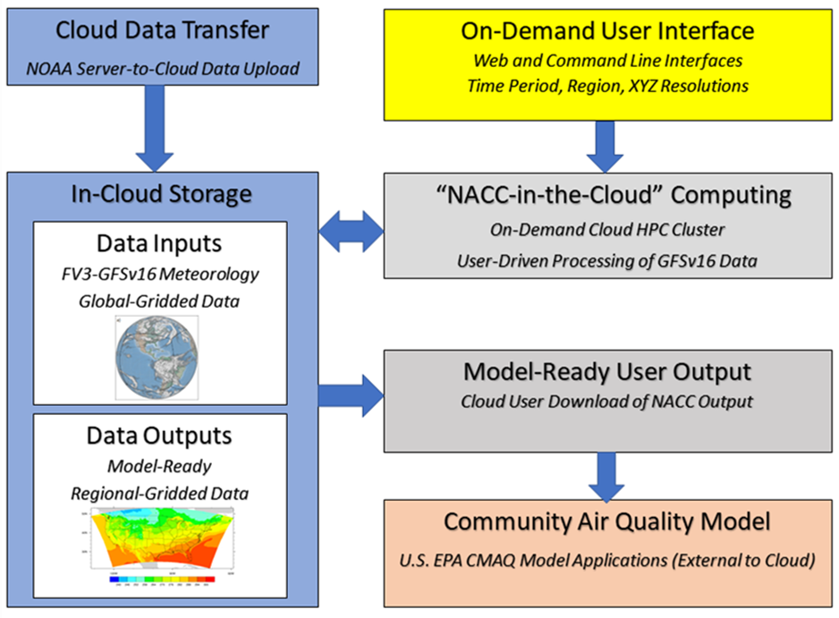
NACC In the Cloud process diagram.
Youhua Tang also attended in person and presented on the “Development of JEDI Based AIRNow and AOD Assimilation Capabilities to Improve RRFS-CMAQ Predictions”
NACC-in-the-Cloud now available for Beta Testing
In relation to Dr. Campbell’s CMAS 2022 presentation (discussed above), the OAR Cloud Incubator project’s collaborative effort at NOAA-ARL has resulted in the release of a new web-based interface to “NACC-in-the-Cloud” for beta testing (https://nacc.arl.noaa.gov/nacc/). More information on the new NACC-in-the-Cloud platform is found below:
NACC-in-the-Cloud information for users:
https://nacc.arl.noaa.gov/nacc/
New Requests for Access May be sent to:
https://forms.gle/jUWFKLyY6WGKySkv6
Please fill out the NACC-in-the-Cloud User Google Form at:
https://forms.gle/ETwKS2qzoHndaruJ9
Air Quality Forecaster Workshop
Youhua Tang attended the air quality forecaster workshop in NCWPC, Oct 20-21 with presentation titled “Development of Chemical Data Assimilation Capabilities to Improve NOAA Air Quality Predictions”
2022 VORTEX-SE/VORTEX-USA Workshop
Temple Lee traveled to Santa Fe, New Mexico from 21-24 October to attend the 2022 VORTEX-SE/VORTEX-USA Workshop. The workshop included nearly 60 participants from NOAA laboratories, cooperative institutes, and universities who met to discuss the current state of VORTEX-SE, which began 2015 to study the environmental factors contributing to severe weather and tornadogenesis over the southeastern US. Breakout sessions included discussions on the complacency in severe weather warnings, plans for future field work in VORTEX-SE/VORTEX-USA, and ways to transition research findings into operational weather forecasting. Results from the 2022 campaign were shared, and plans for the spring 2023 campaign were discussed.
| Papers Accepted |
Accepted for publication in Boundary-Layer Meteorology: Wulfmeyer, V., J. M. Valencia, F. Späth, S. Otte, M. Karlbauer, M. V. Butz, and T. R. Lee, 2022: Estimation of the surface fluxes for heat and momentum in unstable conditions with machine learning and similarity approaches for the LAFE data set.
Evaluation of the NAQFC driven by the NOAA Global Forecast System (version 16): comparison with the WRF-CMAQ during the summer 2019 FIREX-AQ campaign, was accepted for publication in Geoscientific Model Development.
Citation: Tang, Y., Campbell, P., Lee, P., Saylor, R., Yang, F., Baker, B., Tong, D., Stein, A., Huang, J., Huang, H.-C., Pan, L., McQueen, J., Stajner, I., Tirado-Delgado, J., Jung, Y., Yang, M., Bourgeois, I., Peischl, J., Ryerson, T., Blake, D., Schwarz, J., Jimenez, J.-L., Crawford, J., Diskin, G., Moore, R., Hair, J., Huey, G., Rollins, A., Dibb, J., and Zhang, X.: Evaluation of the NAQFC Driven by the NOAA Global Forecast System Version 16: Comparison with the WRF-CMAQ Downscaling Method During the Summer 2019 FIREX-AQ Campaign, EGUsphere [preprint], https://doi.org/10.5194/egusphere-2022-356, 2022.
Abstract. The latest operational National Air Quality Forecasting Capability (NAQFC) has been advanced to use the Community Multi-scale Air Quality (CMAQ) model version 5.3.1 with CB6 (carbon bond version 6)-Aero7 (version 7 of the aerosol module) chemical mechanism and is driven by the Finite Volume Cubed-Sphere (FV3)-Global Forecast System, version 16 (GFSv16). This has been accomplished by development of the meteorological preprocessor, NOAA-EPA Atmosphere-Chemistry Coupler (NACC), which is adapted from the existing Meteorology-Chemistry Interface Processor (MCIP). Differing from the typically used Weather Research and Forecasting (WRF)/CMAQ system in the air quality research community, the interpolation-based NACC can use various meteorological output to drive CMAQ (e.g., FV3-GFSv16) even though they are in different grids. Here we compare and evaluate GFSv16-CMAQ vs. WRFv4.0.3-CMAQ using observations over the contiguous United States (CONUS) in summer 2019. During this period, the Fire Influence on Regional to Global Environments and Air Quality (FIREX-AQ) field campaign was performed and we compare the two models with airborne measurements mainly from the NASA DC-8 aircraft. The GFS-CMAQ and WRF-CMAQ systems have overall similar performance with some differences for certain events, species and regions. The GFSv16 meteorology tends to have stronger planetary boundary layer height diurnal variability (higher during daytime, and lower at night) than WRF over the U.S. Pacific coast, and it also predicted lower nighttime 10-m winds. In summer 2019, GFS-CMAQ system showed better surface O3 than WRF-CMAQ at night over the CONUS domain; however, their PM2.5 predictions showed mixed verification results: GFS-CMAQ yielded better mean bias but poorer correlations over the Pacific coast. These results indicate that using global GFSv16 meteorology with NACC to directly drive CMAQ via the interpolation is feasible and yields reasonable results compared to the commonly-used WRF downscaling approach.
| Papers Published |
Crawford, A., Chai, T., Wang, B., Ring, A., Stunder, B., Loughner, C. P., Pavolonis, M., and Sieglaff, J.: Evaluation and bias correction of probabilistic volcanic ash forecasts, Atmos. Chem. Phys., 22, 13967–13996, https://doi.org/10.5194/acp-22-13967-2022, 2022.
Abstract: Satellite retrievals of column mass loading of volcanic ash are incorporated into the HYSPLIT transport and dispersion modeling system for source determination, bias correction, and forecast verification of probabilistic ash forecasts of a short eruption of Bezymianny in Kamchatka. The probabilistic forecasts are generated with a dispersion model ensemble created by driving HYSPLIT with 31 members of the NOAA global ensemble forecast system (GEFS). An inversion algorithm is used for source determination. A bias correction procedure called cumulative distribution function (CDF) matching is used to very effectively reduce bias. Evaluation is performed with rank histograms, reliability diagrams, fractions skill score, and precision recall curves. Particular attention is paid to forecasting the end of life of the ash cloud when only small areas are still detectable in satellite imagery. We find indications that the simulated dispersion of the ash cloud does not represent the observed dispersion well, resulting in difficulty simulating the observed evolution of the ash cloud area. This can be ameliorated with the bias correction procedure. Individual model runs struggle to capture the exact placement and shape of the small areas of ash left near the end of the clouds lifetime. The ensemble tends to be overconfident but does capture the range of possibilities of ash cloud placement. Probabilistic forecasts such as ensemble-relative frequency of exceedance and agreement in percentile levels are suited to strategies in which areas with certain concentrations or column mass loadings of ash need to be avoided with a chosen amount of confidence.
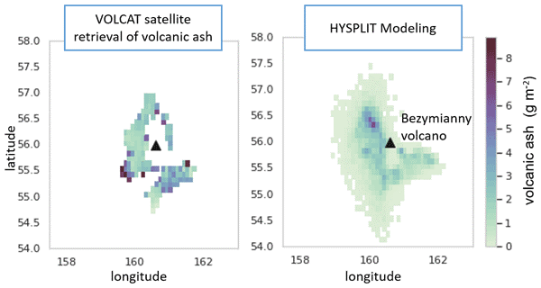
Visual Abstract of: Crawford, A., Chai, T., Wang, B., Ring, A., Stunder, B., Loughner, C. P., Pavolonis, M., and Sieglaff, J.: Evaluation and bias correction of probabilistic volcanic ash forecasts, Atmos. Chem. Phys., 22, 13967–13996, https://doi.org/10.5194/acp-22-13967-2022, 2022.