

ARL Collaborates in Planetary Boundary Layer Study
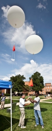
Air Resources Laboratory (ARL) scientists are collaborating with researchers from NOAA’s National Centers for Environmental Prediction (NCEP) on an investigation of the evolution of the urban daytime planetary boundary layer (PBL). The PBL is the mixed layer of the atmosphere closest to the ground that is influenced by many factors, including local topographical features, surface heating, surface type, large-scale weather patterns, and cloud cover. The study will run September 14-22, 2009. ARL’s contribution to the study involves using the existing surface turbulence measurements offered by ARL’s DCNet system and deploying two portable rawinsonde upper air measurement systems at two of the DCNet locations: Howard University and RFK stadium. The goal of this study is to develop an urban meteorological evaluation database to investigate the daytime evolution and spatial variability of the urban atmospheric boundary layer mixing height. ARL’s measurements will join other measurements conducted by scientists at Howard University and the University of Maryland Baltimore. NCEP will provide mixing height estimates from the Aircraft Communications Addressing and Report System (ACARS) profiles, the Cloud-Aerosol Lidar and Infrared Pathfinder Satellite Observations (CALIPSO), and the Constellation Observing System for Meteorology, Ionosphere and Climate (COSMIC) satellites. NCEP also will model predicted boundary layer heights from the Rapid Update Cycle (RUC).
Background: The mixed layer height is a key atmospheric parameter for all models intended to predict conditions at the surface, and especially for atmospheric dispersion and air quality models since the PBL height controls the depth of the atmosphere over which emissions will be diluted. Mixed layer heights exhibit strong diurnal patterns, and the development of the layer is influenced by many factors. It is also generally accepted by the atmospheric science community that the mixed layer depth over urban environments is significantly enhanced from additional surface heating generated from the urban canopy. Although urban regimes have been the focus of considerable research, the evolution of the urban PBL remains somewhat obscure. This study will explore the feasibility of characterizing the temporal and spatial development of the daytime mixed layer height using various remote sensing capabilities.