US Drought Portal Includes USCRN Data
Soil moisture data from the NOAA Air Resources Laboratory’s (ARL) US Climate Reference Network (USCRN) is now publicly available through the redesigned U.S. Drought Portal. The portal, Drought.gov, which is hosted by NOAA’s National Integrated Drought Information System (NIDIS), was re-launched under a revised National Coordinated Soil Moisture Monitoring Network. The new network was designed to integrate soil moisture data from sources across federal and state in-situ networks, such as USCRN; remote sensing data; and other modeling capabilities.
Since 2008, NIDIS, ARL and the National Centers for Environmental Information (NCEI) have collaborated to install and manage not only the soil moisture sensors but also the data acquisition integration, data ingest, and quality control for observations at 113 sites in the CONUS. ARL installs and maintains USCRN, a network of 138 climate monitoring stations with sites across the continental US (CONUS), Alaska, and Hawaii. These stations use high-quality instrumentation to measure the primary variables of air temperature, precipitation, wind speed, soil moisture and temperature (CONUS only), and other secondary variables such as ground temperature, solar radiation, and 1.5m wind speed to ensure quality control of the primary measurements. The entire suite of quality controlled USCRN data, including soil moisture data, are also available via NOAA’s NCEI.
Soil moisture is a critical land surface variable as it impacts a range of climatological, agricultural, and hydrological processes. Soil moisture observations can forewarn of impending drought or flood conditions before other more standard indicators are triggered. These measurements are useful for applications ranging from agricultural monitoring to weather prediction, and from drought to flood forecasting.
The new Drought.gov website is user friendly, with interactive architecture designed to provide actionable information, and easy-to-understand graphics describing current drought conditions and forecasts by city, county, state, zip code, and at watershed to global scales. It provides users with drought impact data for economic sectors such as agriculture, energy, water utilities, tourism and recreation, bringing together interactive maps and data in a user-friendly experience.
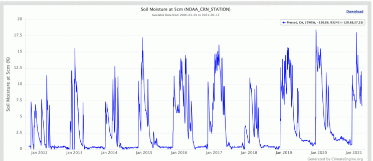
Ten year range of soil moisture measurements for Merced, CA, as captured by USCRN data.