NOAA NESDIS and OAR team up to trace wildfire smoke
October 13, 2020
Margaret Simon
Summer 2020 wildfires were unprecedented in duration, their intensity and the area burned. The fires that are raging in California, Oregon, and Washington are unprecedented in terms of their duration, their intensity and the area burned; the most intense to date are the August Complex, North Complex, and Creek fires, which have so far consumed more than 824,000, 287,000, and 248,000 acres respectively and are listed as the top three fires by an interagency incident information system website.
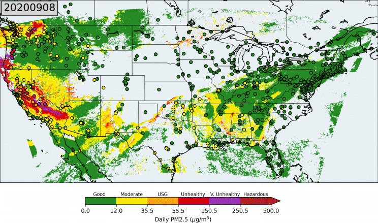
While the impact of smoke is felt the most in the vicinity of the fires, where PM2.5 concentrations are highest, smoke that rises high enough to get caught in the jet streams will travel long distances. Smoke particulate also gives rise to spectacular sunrises and sunsets and, when it mixes into the boundary layer, impacts local air quality. Poor air quality is a significant risk to public health. The US EPA estimates that 34,000 premature deaths a year could be prevented if the nation could lower annual levels of particle pollution by 1 µg/m3. The U.S. Environmental Protection Agency (EPA) defines air quality using different categories, ranging from good to hazardous based on the concentration of particles smaller than 2.5 micrometers in median diameter, a size small enough to enter the human respiratory system and cause lung tissue damage and cardiovascular disease. These particles are referred to as PM2.5.
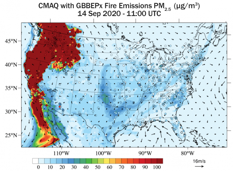
The series of small particulate (or PM2.5) maps derived for September 8, indicate that when FRPs peaked at about 1.2 million megawatts, PM2.5 concentrations were also high: at unhealthy (> 55.5 µg/m3), very unhealthy (150.5 µg/m3), and hazardous (250.5 µg/m3) levels in central California, western Oregon, and northern Washington state. By September 12, the region with unhealthy levels of PM2.5 concentrations extended east into Idaho and Nevada while cloud cover caused gaps in PM2.5 estimates in the central U.S. On September 14, a series of visible satellite imagery from GOES-16 satellite showed smoke spreading across the region covering Nevada, Wyoming, South Dakota, Minnesota, Iowa, Missouri, Nebraska, Indiana, Ohio, Pennsylvania, New York, New Jersey, Maine, and New Brunswick in Canada.
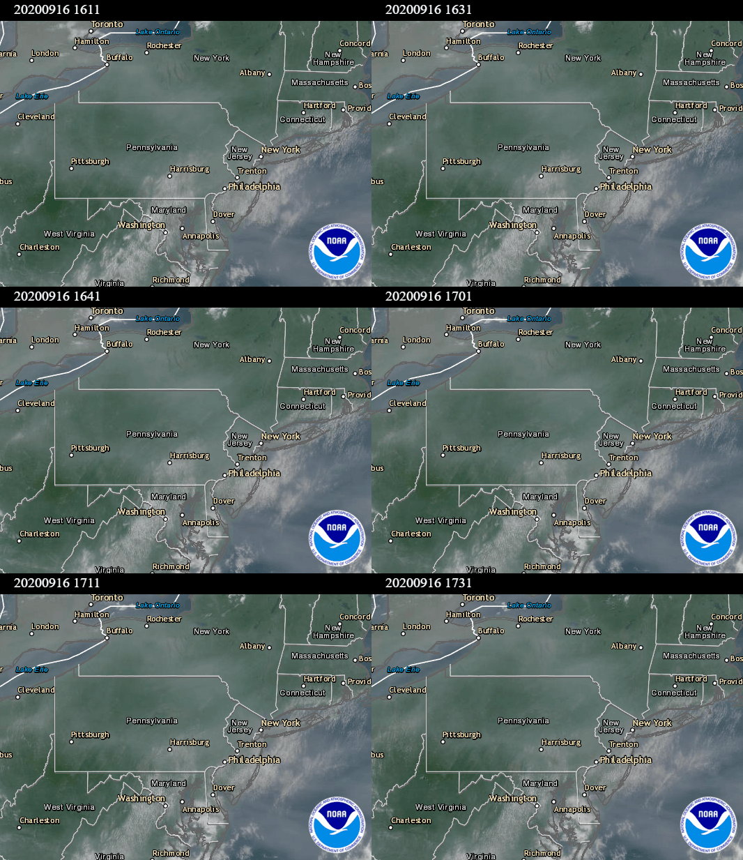
As the smoke continued to move into the mid-Atlantic states, colleagues at the University of Maryland Atmospheric and Oceanic Science (supported by Maryland Department of Environment and National Institute of Standards and Technology) and the NOAA Air Resource Lab coordinated with the NOAA/NESDIS STAR aerosol team to design an instrumented aircraft flight path to directly measure the smoke on September 16. In addition to the VIIRS aerosol products, the OMPS aerosol index and the GOES-16 satellite’s 10-minute visible and aerosol imagery movies provided evidence for the location of smoke. Based on these NOAA satellite imagery and other sources of information, the University of Maryland Department of Atmospheric and Oceanic Science joined with NOAA’s Air Resource Lab team to fly in a Cessna aircraft to make smoke optical and chemical measurements that will help the scientists understand the aerosol and ozone formation processes. This team, led by Dr. Xinrong Ren, did an aircraft spiral northeast of Baltimore, Maryland, and found the smoke between 1.5 and 2.5 miles above ground. Reporting a mean concentration of 62 µg/m3 and only trace amounts near the surface, the AOSC team validated the VIIRS satellite-derived PM2.5 map that showed the conditions on the ground were good (PM2.5 < 15 µg/m3).
“We were really pleased to get the satellite images,” said Russ Dickerson, professor of atmospheric chemistry at the University of Maryland. “They allowed Graduate student Hannah Daley to fly right to the dilute smoke plume, profile up through it, and measure its optical and chemical properties. It was too high an altitude to pose a hazard to the health of people on the East Coast, but it shows that the fires had a massive impact on the atmosphere over a broad area.
“Satellite data are essential for forecasting air quality during wildfires,” said Dr. Daniel Tong, associate professor of atmospheric chemistry and aerosols at George Mason University and a research scientist at NOAA’s Air Resource Lab.” The National Air Quality Forecast Capability, operated by the National Weather Service, relies on satellite products, including fire detection and emission estimates, to drive its models. Federal and state agencies use these numerical forecasts to support their own missions, including issuing local air quality alerts.
Collaborators and more info on this project are on the NESDIS STAR website.


