

Usability Improvements to HYSPLIT Provides Additional Location Data
November 16, 2020
Margaret Simon
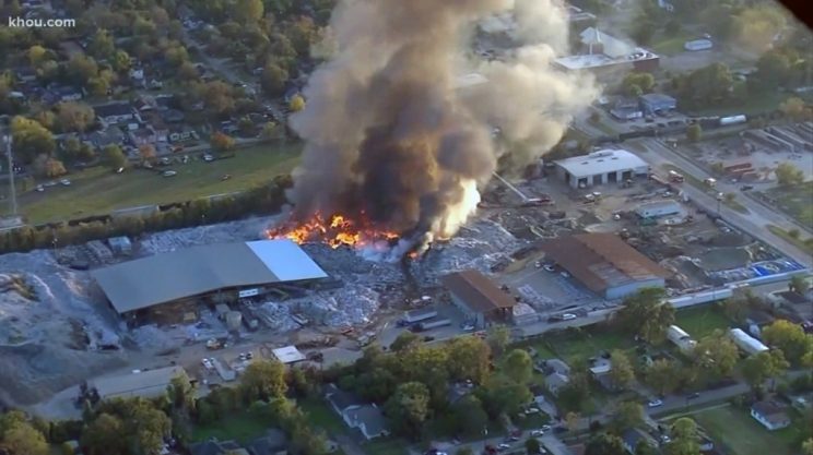
Arial view of November 11, 2020 recycling plant fire in Houston, Texas. (Image courtesy of KHOU).
When fire erupted at the Independent Texas Recyclers on November 11, in Houston, Texas, local fire and HAZMAT crews were dispatched to respond. Pungent black smoke poured from the fire along with potential toxins. A shelter in place order was issued for Northeast Houston as HAZMAT monitored the air and water; anyone within a half mile radius was advised to stay inside with windows closed as teams battled the blaze. The acrid smell had already alerted residents to the seriousness of the situation. NOAA’s Houston/Galveston Weather Field Office (WFO) knew the origin of the fire, but information about the structures, proximity to homes, and terrain was critical to respond in the most efficient manner.
In an industrial area of Texas, this event was far from uncommon. “Unfortunately, these types of events occur on a fairly routine basis here” according to Brian Kyle of the Houston WFO. However, there are other “larger and more concerning refinery and chemical plant releases and hazmat events,” and knowledge of the contents of the plant would better inform not only the approach of the responders, but also the issuance of public health alerts.
Now, there are new HYSPLIT tools to help them locate the source and content of industrial smoke plumes. Several usability improvements have been incorporated that expand on the ability to use HYSPLIT simulations to enable precise and quick reaction by local response agencies. The HYSPLIT interface has more tools to determine location and terrain information, and include multiple navigation means such as location or street address. New options for satellite views, with an option for MODIS/VIIRS satellite imagery, is also available to identify specific industrial structures and equipment as well as potential runoff problems. Also in progress is a cloud option that is being tested by NOAA Web Operation Center (WOC) and ARL that will allow 24/7 access to all WFO’s.
Initially suggested by the Houston WFO, these interface changes are available at the ARL development site: https://www.ready.noaa.gov/hysplitcameodev/.
Interest in applying HYSPLIT to more short-range problems increased following 9/11 with a request from the National Weather Service for routine HYSPLIT forecasts at a number of fixed locations. The on-demand, web hosted capability hosted at NOAA’s 24/7 Web Operations Center was established to replace a cumbersome and a dedicated system for Weather Forecast Office (WFO). This interface, developed in collaboration with the National Ocean Service’s Office of Response and Restoration, links HYSPLIT with a chemical database permitting the WFO to select a realistic emission scenario and create output graphics linked with human exposure guidelines.
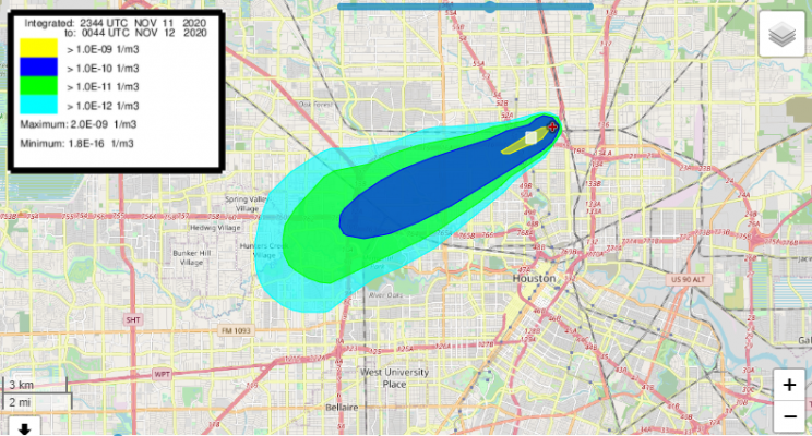
HYSPLIT Atmospheric Dispersion predictions from for Nov 11, 2020, northeast Houston area smoke plume. The WFO provided these information to the Houston Office of Emergency Management to inform the public alerts and response options.