A direct link to the ECMWF data server
is not included in the GUI. Access to the data archive
requires acceptance of their copyright agreement. Once through this step, three data files should
be obtained for the data period of interest. All fields should be four times-per-day (0,6,12,18).
At a minimum, select geo-potential, temperature, u- and v-velocity, vertical velocity, and relative
humidity, at all pressure levels within the lower troposphere. The surface variables should include
the 2-m temperature, 10-m u- and v-velocity. Because surface pressure is not available (only mean
sea-level), the geo-potential invariant field (terrain height) must also be retrieved.
Converting from GRIB to HYSPLIT
|
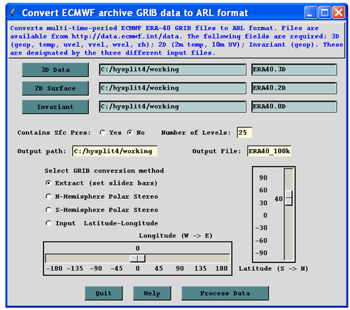
Open the ECMWF archive conversion menu from the Meteorology / Convert to ARL
GUI and set the file names for the three
GRIB data sets. Define the name of the output data file if something other than the default name
is required. In this example, the data will be interpolated to a 100x100 100-km resolution
conformal map projection centered about the point indicated by the slider bars. The last option
under the GRIB conversion does no interpolation and outputs the data on the same grid as input,
but in a HYSPLIT compatible format.
|
|
|
The ECMWF menu calls the generic grib2arl converter program. This program has several
additional options that can be set through the command line that are not available through
the GUI. This program can handle all latitude-longitude NOAA as well as ECMWF GRIB files
containing single or multiple time periods. For example the –n option can be used to
change the size of the interpolated grid to something other than the 100x100 default.
|
|
Usage: grib2arl [-options]
 -i[primary grib data: file name {required}]
 -s[supplemental grib data: file name {optional}]
 -c[constant grib data: file name {optional}]
 -x[subgrid extract center longitude {-80.0}]
 -y[subgrid extract center latitude {60.0}]
 -g[output projection  0 :conformal extract
                       1 :fixed northern hemisphere polar
                       2 :fixed southern hemisphere polar
                      {3}:lat-lon global grid (as input)
                       4 :lat-lon extract grid
 -n[number of (x:y) extract grid points {100}]
 -k[number of output levels including sfc {16}]
 -p[surface defined by {1}:pressure or 0:terrain height]
 -q[analyze grib file {0} or use saved configuration: 1]
 -z[zero initialization of output file 0:no {1}:yes]
|
|

